MAKA'ALAE lAND RETURNED TO hĀna community
Ke Ao Hāliʻi is pleased to announce that in December of 2021, KAH and partners completed the purchase and protection of 30.34 acres at Makaʻalae along Maui’s Hāna coast. The Maka’alae land is sacred (wahi pana) because of the Native Hawaiians that lived here. It includes historic sites from ancient times through the sugar plantation area, open space pastureland for prime cattle grazing, and a stunning coastline that is used by local families for subsistence food gathering and cultural practices.
The land is permanently protected with a conservation easement co-held by Hawaiʻi Land Trust and County of Maui. “Mahalo Ke Akua for helping us find the way and blessing us with purchasing this ‘āina, and giving a chance for the descendants and community to mālama this special place. Mahalo to the Hāna community, all our supporters, the State of Hawaii, County of Maui and Hawai‘i Land Trust for protecting the land for future generations so our culture and way of life can be preserved,” said John (Irish) O’Hara, a lineal descendant and resident of Maka’alae and Vice-Chair for Ke Ao Hāli’i.
This coastal land is a crucial part of what keeps the Hawaiian culture alive in Hāna.
ACCESS Policy
Origin of name
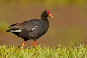 The Hawaiian gallinule (Gallinula galeata sandvicensis) is an endangered chicken-sized water bird in the rail family (estimated current population 300 birds with, restricted distributions on Oahu and Kauai) is commonly known as a mudhen, and in Hawaiian as the `alae `ula (“burnt forehead” - for its prominent red frontal shield). Maka'alae is Hawaiian for "the mud hen's eye."
In Hawaiian mythology the alae'ula was regarded as deity and was the keeper of fire for the gods. There are two legendary versions of how this bird brought fire from the gods to the people. One tells of the trickster Maui forcing the alae to release its secret of fire; the second, more generous, is that the alae took pity on humans and stole fire from the gods giving it to humans for warmth and cooking. Both versions associate the red frontal shield to the effects of fire. The origin of naming the point "Maka'alae" is unknown.
Maka'alae description
Maka'alae Point is commonly regarded as the coastal lands located between the Kapia and Waiohonu streams. It is composed of majestic open fields bordered on the south by Waioka pond (now under Hawaii State land title), on the west by the Waiho'i Valley coastal escarpment and the north by the Kapia Stream. On the east the shoreline includes a geologically sunken black lava beach, rocky cliffs, numerous tidal pools, and a stand of Cook Pines which gives the area its local name, "the pines or pine trees".
Historically it was part of the sustained Hawaiian subsistence agri-marine culture from 800 AD until the land tenure transition (1850-1860) when sugar became a commercial export commodity. In the 1940's sugar profits declined eventually resulting in discontinuation of cultivation. Today, the only remnant of this era is the unrestored concrete foundation of the Maka'alae sugar mill in brush overgrowth. Since 1947 the area has been used commercially for cattle ranching and local cultural uses. Today it is beloved by local residents for shoreline fishing, diving, gathering and walking. As well as connecting and paying respect to past generations that have done the same.


Maka'alae art
Over the years, Maka'alae has been depicted in artwork, of which here are some examples:


mĀlama Maka'alae
DONATE NOW to help us manage these lands that have been purchased and placed into conservation.